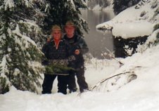
This is a trip Linda and I took down the Lower Salmon River in the summer of 2005. The story as seen here was published in The River Journal in two part after the trip. The Picture is Linda and I above Blue Canyon On the Lower Salmon.
As I entered the chute of the rapid, the raft, for a reason I don’t understand, turned around so it was facing the shore as we went through. I started to push hard on the oars. That’s harder than pulling, so the effort I needed to get into the eddy was hard. We were over the rapid but the current was still churning white. We started past the sandy shore where I wanted to land, pushing until muscles that weren’t used to this kind of activity started to scream back. As I passed the other boats from our party, pulled up on the bank, I nosed into the eddy but the speed still took the boat to a rocky point at the far end of the sand bar. The 14-foot, blue inflatable raft hit full broadside into the rocks. They stopped us and several guys from shore ran out and grabbed the lines; we were home for the night, no damage, no injuries and with everyone we started with.
Like most people, I find learning a new skill in front of an audience uncomfortable at best and downright embarrassing at worst. But everyone was encouraging. I had to remind myself that the intention was to land here… and I did. Maybe not with grace and ease, but I had landed here.
I wanted to lie down in the sand with my hands behind my head and look up at the hills and sky. I laid back and, as my hands traveled to the back of my head, my right arm stopped about halfway there. A pain blasted through my pectoral muscle from pushing so hard on the oars and wouldn’t let that arm move any higher. My excitement of the moment hid my discomfort. So, I had to settle for sitting up…. and drinking a cold beer. I was where I wanted to be and my arm moved far enough for the task at hand—drinking beer— so all was well.
I had never been on a raft trip and the new adventure was proving to be exhilarating. As usual when facing a new challenge, the excitement was mixed with a bit of anxiety.
This is a quite a safe river in late July and our trip leaders were all very experienced so I felt secure under the circumstances. In addition, there were several skilled river runners in the party. However, the force of whitewater always commands respect and diligence when making passage. As my landing experience showed, even a moderate rapid with current can spell disaster to the inexperienced or unwary.
We had arrived at Pine Bar, on the Lower Salmon River, that morning. Once there, coolers full of ice, food, beverages and enough water for 20 people for four days were placed on the arid river’s edge, as the rafts were inflated and rowing frames attached.
I looked at how different this place was from home just a few hours to the north. Vegetation was sparse and mostly brown. Few trees were standing on the hills and the brush that chokes our forests was not to be found at all.
Our plan was to take everything we took in out with us. We knew that for this to remain the pristine area it is we would have to “take only pictures and leave only footprints.” The valley is so dry that anything left, even buried, will last for decades.
The Nez Perce Indians who lived on the Salmon River called it “Natsoh Koos," which means "Chinook Salmon Water" after the fish that once thrived here. Early explorers dubbed it the "River of No Return" due to the difficulties they experienced trying to transport wooden boats upstream through roaring rapids. Lewis and Clark attempted to use the river as a waterway to the Pacific Ocean, but were thwarted in their attempt because of all the whitewater.
Now it was our turn at the river. When we were loaded and in the water it occurred to me the only difference between adults and children when they get in the water is children take longer before splashing each other than adults do. It was happy fun that was a major part of the next four days.
As I sat on the fine white sand, listening to good-natured teasing and joking from my expedition mates, I couldn’t help but wonder what the rocks and sand would tell me if they talked. An adventurous spirit exudes from the canyon walls and piques my anticipation of what is to come.
It’s possible that people passed, or maybe lived, here as long as 8,000 years ago. What history have these towering rock structures seen and heard?
This waterway is the longest (425 miles) free-flowing river in the lower U.S., one of the few in the nation that contains no dams. It flows through the second deepest gorge on the continent. Only the Snake River in Hells Canyon is deeper. The Salmon's canyon is deeper than the Grand Canyon, and for approximately 180 miles, the Salmon Canyon is more than a mile deep.
I had just experienced a minor miscalculation and learned how fast one can get in trouble even in a small rapid.
Whitewater rapids are classified from 1 to 6; this trip features 1 through 3, meaning only some technical skill will be needed.
As we continued, we passed over several rapids, some that created a great deal of excitement, but when we came to Snowhole Canyon and the rapids of the same name we put into shore to scout. This was the first time we had scouted before we dropped over.
The experienced members of our group said that it changes. In high water the turbulence and the drop requires acute attention. In lower water rocks are exposed in the middle of the fast-moving water and rafts need to cross the current in the drop to be safe. On this day the water was between those extremes. This is a class 3, but a boat against a rock can still be pushed, damaged or even flipped over, dumping its occupants and cargo into, and at the mercy of, the torrent.
Back on the water we started getting into position. The first raft over entered the current, adjusted slightly by an expert oarsman, and disappeared over the drop. It took a minute but they re-appeared in the pool below and we knew they were safe.
The next craft over was an inflatable kayak. I had been eyeing this craft during the float and wanted to try it. The couple in it situated the little vessel just right and dropped out of sight. We sat and waited for what seemed forever. Cheers from people still on shore told us they were safe.
This was going to be the biggest water I had been through. With my previous experience in mind, I was quite comfortable when one of our boat mates took the oars.
He set us up just right. The raft accelerated and bounced slightly. As we dropped over the top, the hole and the high curl we were entering came into view. In the surge of white water I felt our ride twist, stretch and bend. Water was over and in the boat, obliterating our view. When it cleared, we were in the pool below the drop. Wet, delighted and safe below the roar of Snowhole Rapids.
After the thrill of Snowhole Rapids, my trip-mates and I were again floating lazily down the Salmon River, this pool and drop paradise that was the backdrop to my first whitewater rafting trip.
As we continued down the Lower Salmon we saw stone huts and remnants of mining equipment from the old days, when Chinese miners used this as their highway. I remembered reading of wooden scows with a two-man crew making their way around the rocks and through the valleys in an attempt to get rich in this primitive land. Those boats weren’t as forgiving as our inflatable rafts. A slight mistake and they could be broken into kindling by the force of the water.
Throughout the trip I had been eyeing an inflatable kayak and, one afternoon, Linda and I got a chance to spend a little time in it. A little to my surprise, I could never get comfortable in it as others had. We were working the boat in a slight rapid when a wave from the side hit me and washed me overboard. I didn’t see it coming at all and Linda didn’t know I was gone until I called to her. One of the rafts came over and helped me up. The discomfort of an unusual sitting position combined with the ease in which I was dumped, left me kind of unnerved.
We floated on, knowing that China Bend Rapids, a big drop, was just ahead. Linda and I talked of giving up the kayak for the safety of a raft. She felt I needed to “get back on the horse.” I wasn’t so sure.
When not dealing with heavy currents, we studied the basalt columns as we passed. Some were perfectly vertical. Others leaned. In a couple of places the columns were on their side and we could only see the ends stacked like cordwood drying in hot sun. A few looked as if some huge force had pushed on them, leaving them with a face that was strangely distressed and tortured.
Colors in the rocks ranged from red to blue to a turquoise green. Sometimes they were carved and polished, like freeform sculptures standing right next to a rugged, uneven stone.
Since our first day on the river we had been listening to the descending song of the Canyon wren. Those little brown birds were flitting in and out of the rocks trying to hide, yet were giving away their location with their unique song.
It appeared to be a good year for Chukar production, or reproduction that is. The hens, with their half-grown chicks, made large coveys that were crawling over, under and though the rocks as we went by. When the water was quiet we heard their “chuck chuck” voice coming from both shores most of the time.
And then, over the sound of birds, we heard it. My adrenaline started flowing faster than a waterfall. I knew it was the roar of China Bend Rapids.
China’s main chute was on the left between shore and a large rock that stuck several feet out of the water. The rafts had to make that run just right to be successful. In the kayak we could run further out, but the turbulence was going to be quite extreme for our skills.
We dropped over just to the right of the rock and shot across the river toward the opposite shore. Water was hitting us from every direction and at one point I grabbed a strap and hung on. We bounced and churned until we came out the bottom.
I was hoping to hear cheers over the noise of the water. Sure enough they started, and then stopped with a gasp. We spun the little inflatable around just in time to see one of the rafts hit the big rock. With the driving force of the water slamming against the boat and the stone trying to stop it, it rolled up, ever so slowly and flipped upside down into the chute.
I saw the oarsman’s head pop up in front of the upturned raft. He then disappeared. No one else from the boat came into view. As we pulled closer, he remerged from one side of the inverted craft. His experience had taught him to look to see if anyone was still under the boat. It was empty. He came out and moved to the stern. There he found his wife and the other couple who had been riding inside. Fortunately they all washed clear of the rock and floated out of the whitewater into the pool below. Our boat was lowest in the water, so Linda and I started looking for debris, but found nothing.
With one man on the bottom of the upturned boat and two more in the water, they righted it on just the second try. Cheers went up as the crew climbed back in and all were ready to continue.
We had been given a reminder of the power of even moderate rapids. It was one of those whitewater incidences that can happen even to a careful, experienced oarsman. The only loss was one of Rachel’s sandals. Of course, the loss of one sandal is only a subtle difference from a loss of a pair.
Geologists say of Blue Canyon, Lower Salmon River, “The rocks in this canyon are the oldest in the Lower Salmon, at about 200 million years of age. They contain a variety of mollusk shells in limestone beds.”
It’s through this canyon the last few miles of the Salmon River flows. We made our way through the old blue-black rocks, sometimes feeling like we could touch both sides at the same time. It’s a slot, sometimes only 70 to 80 feet wide and 800 to 1,000 feet high.
Above us on narrow ledges were Rocky Mountain Big Horn Sheep bounding about like children on a flat grassy playground.
At the slide area I marveled at boulders too big to be hauled by anything man has been able to create, yet looking as if they were casually tossed onto the slope, and could be pushed on into the river with minimal effort. During high water, I understand, this area is too turbulent to pass, even though there are no real rapids.
As we exited a bend near the end of Blue Canyon a high wall appeared, crossing in front of us. It was the west side of Hells Canyon.
Floating out into the Snake River we looked back at the confluence of those two huge canyons… one of the most awesome places I have ever been.
The two deepest canyons on the continent, I think Steve put it best: “I realize how insignificant I am when I see those canyons.”
Now Oregon was on our left and Idaho on our right. Soon we would cross into Washington to the west and land for the last time.
We had traveled over 60 miles on two rivers in three states. Twenty people together, forced, by choice, into a rather feral atmosphere and yet somehow respecting each other’s strengths and weaknesses. And having a wonderfully fun time, often laughing until we hurt. We also respected the pristine rivers and valleys we had come through. We really did “take only pictures and leave only footprints in the sand.” Except, of course, for one of Rachel’s sandals, which by now is probably trying to choke a turbine in a Columbia River dam.
I had learned enough of this new challenge to know I wanted to learn more. I still can’t figure out why that raft turned around on the first day. Nonetheless, the power of the river and the ghosts of the canyon challenging the ghosts of my past had created a rich experience.